PA Has Zero Alcohol Tolerance Policy while operating a snowmobile. Please be smart and safe.
To Donate to the general/groomer fund click here for payment instructions.
West Creek Recreational Trail Association is looking for volunteers to help maintain sections of trail.
This is the section between West Creek and Emporium.
Rich Valley Road – Shippen Township approved the use of the road from the county line to Driftwood branch of the Sinnemahoning Creek bridge. Please be respectful and ride responsibly.
Game land trails open 3rd Sunday in January Until April 1.
DCNR, State Forest and State Park Trails are open day after rifle deer season and close April 1.
As long as there is enough snow cover, snowmobile trails open the day after the last day of Pennsylvania’s regular or extended rifle deer season, and close April 1 or earlier as determined by the district forester or park manager.
Allegheny National Forest open day after rifle deer season and close April 1. Verify your maps.
The Allegheny National Forest has about 365 miles of snowmobile trails in interconnected loops. Trails are open mid-December through April 1, conditions permitting. Contact the Supervisor’s Office Allegheny National Forest at (814) 723-5150 for additional information and trail condition reports.
Bradford Ranger District (814) 362-4613
Marienville Ranger District (814) 927-6628
Thanks to the groomer operators who dedicated their time to keeping the trails smooth.
Allegheny National Forest Trails
GPS Trailmasters Map – Eastern US/Canada Snowmobile Trails
There is a new trail reroute off the West Creek Rails to Trails that connects the Elk State Forest in northern Elk County/southern McKean County. With the generous cooperation of private landowners and club work, a 7-mile trail connector will restore snowmobile access between northern Elk County, southern McKean County, Saint Marys, Emporium, and Sproul State Forest. We must emphasize that the property owner will not tolerate off-trail riding on any portion of the property and doing so will result in the loss of the connector trail.
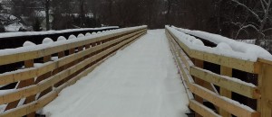
The Railroad bridge over West Creek in Emporium is now open (provided there is snow).

The club has put all new decking on the existing railroad ties. Please proceed with caution and go slow since this is a residential area, but this opens up a whole new location for riding, food, and fuel.
There is no fuel from the trails in St. Marys. If you are coming from Emporium, fill up there(Quick Fill or Fuel On) prior to continuing on the railroad grade. End of West Creek trail in St Marys requires some road riding to get to Sunoco on Washington St.
Free App for Snowmobilers (Polaris App)
GPS capabilities on your phone.
Some capabilities are:
– See your current GPS location
– View maps of U.S. snowmobile trails combined with lodging, restaurants, fuel, Polaris dealers, medical, snow depth, weather, and any waypoints you save overlays
– View snow cover, weather conditions and advisories for any U.S. location
– Track and save multiple snowmobile routes, plus trailheads, scenic spots and other waypoints on the trail, complete with photos and descriptions
– View stored maps on the trail or outside data coverage, thanks to automatic map caching
– Sync your account data to the cloud and across multiple devices
– Export route data in GPX or CSV format
*Continued use of GPS running in the background can dramatically decrease battery life.
You can setup/sign in with an email address to be able to set waypoints/track where you have been etc, or use it as a guest just to get maps/locations/etc.
Snow Trails for Android
Snow Trails for iPhone
*** Use any maps/gps coordinates/software at your own discretion. Shown may or may not be public trails.

